
Daily Stack 20251031 – Hurricane Melissa, Where did It Come From?
And role of climate change: they are getting angrier with stronger winds, heavier rains, and slower crawls.

“ZCZC MIATCUAT3 ALL
TTAA00 KNHC DDHHMM

Hurricane Melissa Tropical Cyclone Update
NWS National Hurricane Center Miami FL       AL132025
1000 AM EDT Tue Oct 28 2025

...CATASTROPHIC WINDS MOVING ONSHORE SOUTHERN JAMAICA...
...LAST CHANCE TO PROTECT YOUR LIFE...
...1000 AM EDT POSITION UPDATE...

THIS IS AN EXTREMELY DANGEROUS AND LIFE-THREATENING SITUATION! TAKE
COVER NOW! Failure to adequately shelter may result in serious
injury, and loss of life. Residents in Jamaica that experience the
eye should not leave their shelter as winds will rapidly increase
within the backside of the eyewall of Melissa.

To protect yourself from wind, the best thing you can do is put as
many walls as possible between you and the outside. An interior room
without windows, ideally one where you can also avoid falling trees,
is the safest place you can be in a building. You can cover yourself
with a mattress and wear a helmet for added protection.

NOAA Hurricane Hunter Aircraft find that Melissa continues to
strengthen with maximum sustained winds of 185 mph (295 km/h).The
minimum central pressure has fallen to 892 mb (26.34 inches) based
on NOAA and Hurricane Hunter Air Force Reserve aircraft data.

The next update will be provided with the full advisory package at
1100 AM EDT (1500 UTC).

SUMMARY OF 1000 AM EDT...1400 UTC...INFORMATION
----------------------------------------------
LOCATION...17.7N 78.1W
ABOUT 45 MI...70 KM SSE OF NEGRIL JAMAICA
ABOUT 255 MI...410 KM SW OF GUANTANAMO CUBA
MAXIMUM SUSTAINED WINDS...185 MPH...295 KM/H
PRESENT MOVEMENT...NNE OR 20 DEGREES AT 7 MPH...11 KM/H
MINIMUM CENTRAL PRESSURE...892 MB...26.34 INCHES

$$
Forecaster Kelly”
https://www.nhc.noaa.gov/archive/2025/al13/al132025.update.10281400.shtml
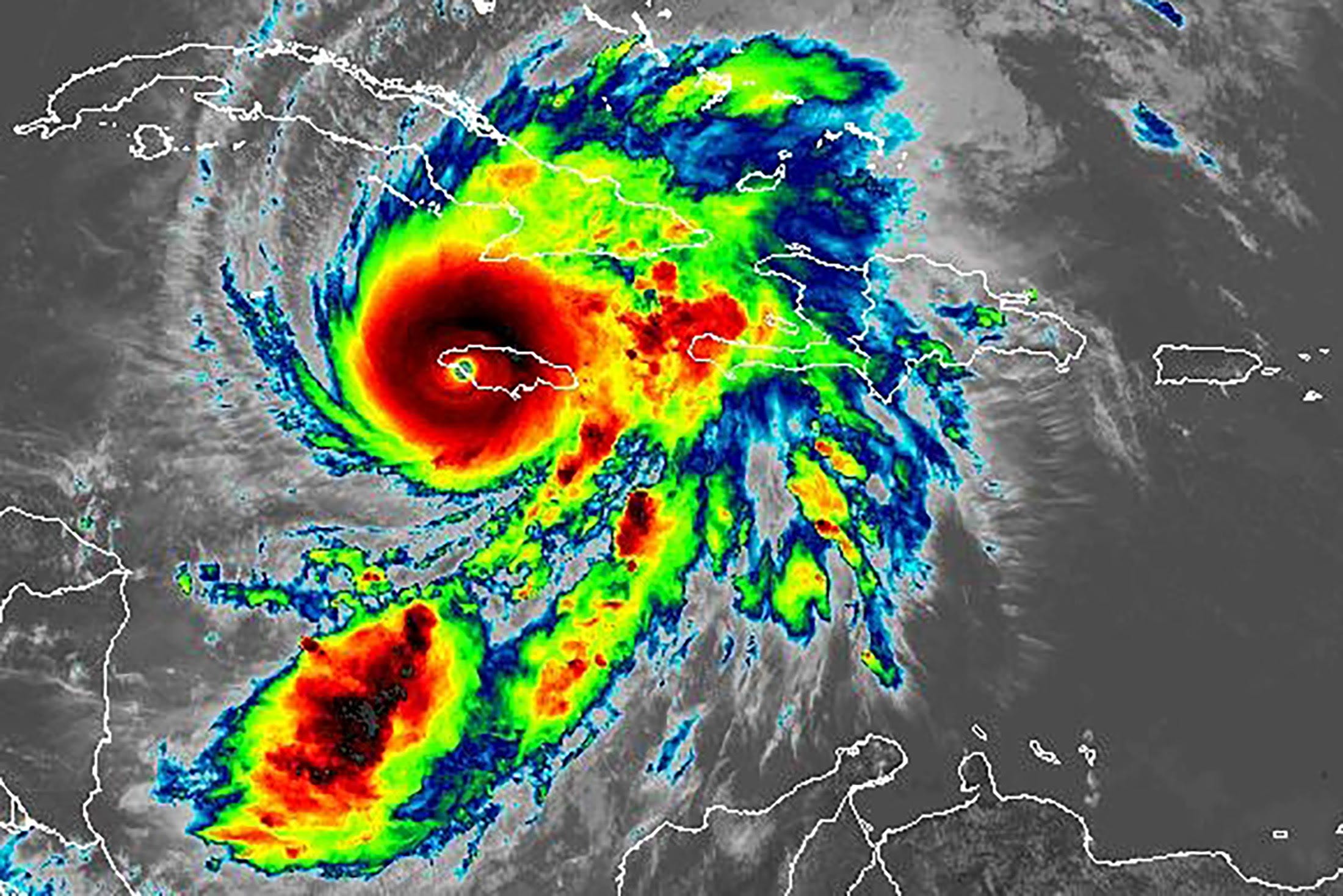
Figure 1: NOAA, 28 October, 2025: Hurricane Melissa over Jamaica
Hurricane Melissa hit Jamaica as a Category 5 hurricane and the strongest storm on record to hit the island on Tuesday 28 October, 2025. It caused widespread destruction across the island with winds nearing 300 km/h (186 mph), heavy rains and storm surges (https://globalnews.ca/news/11500054/hurricane-melissa-jamaica-destruction-video-photos/). And with such devastation, there has been the tragic loss of life.
In the news we see the formation of hurricanes in the Atlantic Ocean, Caribbean Sea or Gulf of Mexico and then we follow their path as it becomes threatening or back out to sea in the mid-Atlantic. We usually see this formation from a “tropical disturbance of interest” that has been lurking in these waters. But where do these tropical disturbances come from? Do they just spontaneously happen?
Forever Connected to Africa
As with many things, hurricanes also have their roots in Africa.
The temperature difference between the Sahara Desert and the cooler Gulf of Guinea creates a jet stream called the African Easterly Jet. You will recall how our post on the polar vortex talked about how temperature differences between two regions creates the Polar jet stream (https://bitsbytesclimatescience.substack.com/p/daily-stack-20250219). The African Easterly Jet flows from east Africa to west Africa and migrates from south to north and back south throughout the year.
Because it flows from east to west in the northern hemisphere, as the jet stream flows north then south again, it forms a wave-like flow and creates a partial anticlockwise or cyclonic flow at the crest of the wave. The crests of the jet also results in a convergence of the air flow causing an upward motion of the air (as there is a ground boundary).
This convergence, cyclonic flow and warm moist rising air results in a wave-like cloud formation along the jet. This is seen in the two figures below.
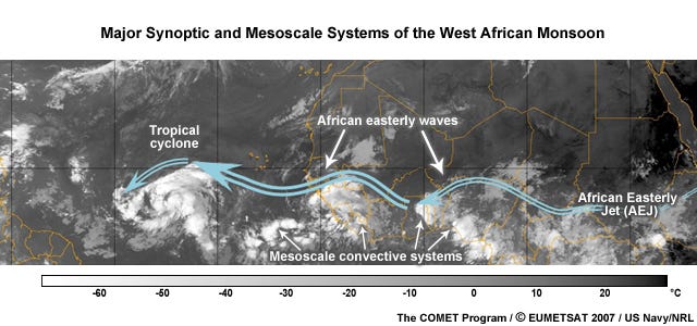
Figure 2: The African Easterly Jet (blue arrows) that then creates easterly or tropical waves; http://kejian1.cmatc.cn/vod/comet/tropical/jetstreams/navmenu.php_tab_1_page_4.3.0_type_text.htm
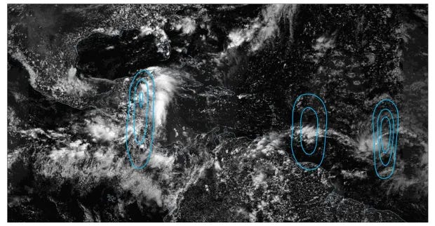
Figure 3: Tropical waves: https://www.sun-sentinel.com/wp-content/uploads/2025/09/TFL-L-AI-hurricane-02.jpg?w=620
Five Key Conditions for Hurricane Formation
If the crest of the tropical wave grows it can create the right conditions for deeper convection and hence lower pressure in the area. This further intensifies the tropical wave and with more convective activity can result in a tropical disturbance. This leads us to the following five key conditions needed for hurricane formation.
The tropical disturbance. To grow this disturbance, the following are needed:
A sufficient Coriolis force. The earth’s rotation creates the Coriolis force needed to generate the rotation of the growing disturbance. This force strengthens as one moves away from the equator. Therefore, tropical storms typically form about 500 km (311 miles) or 5° latitude from the equator.
Sea surface temperatures of at least 26.5° C (80° F) to a depth of 50 m (160 feet) to provide the moisture for convection.
High humidity. A warm moist tropical atmosphere provides the moisture and unstable atmosphere for convective thunderstorm development.
Weak wind shear with height. A strong difference in wind speed and its direction with height prevents the formation of deep vertical convection and therefore thunderstorm development. Such wind shear can easily destroy eye formation.
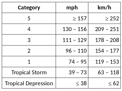
The Different Categories of Tropical Cyclones and Hurricanes – The Saffir-Simpson Scale
As these tropical disturbances become more organized and increase in intensity, they form a tropical depression. With further intensification, a tropical depression then progresses into a tropical storm, then into a hurricane.
The well known Saffir-Simpson wind speed scale classifies tropical cyclones according to the maximum sustained winds (https://en.wikipedia.org/wiki/Saffir%E2%80%93Simpson_scale):
The Role of Climate Change
Global warming is causing hurricanes to be more devastating. Other than the Coriolis force, the remaining four key conditions are being amplified with our warming world.
Sea surface temperature for the tropical Atlantic Ocean, Caribbean Sea and Gulf of Mexico during the hurricane season from June to November, for the period 2021 to 2040, are expected to be near and above 30° C (86° F) (see the figure below). In fact this is the expected temperature for much of the tropical regions of the Indian and Pacific Oceans.
We can therefore expect ideal sea surface temperatures for strong hurricane development.
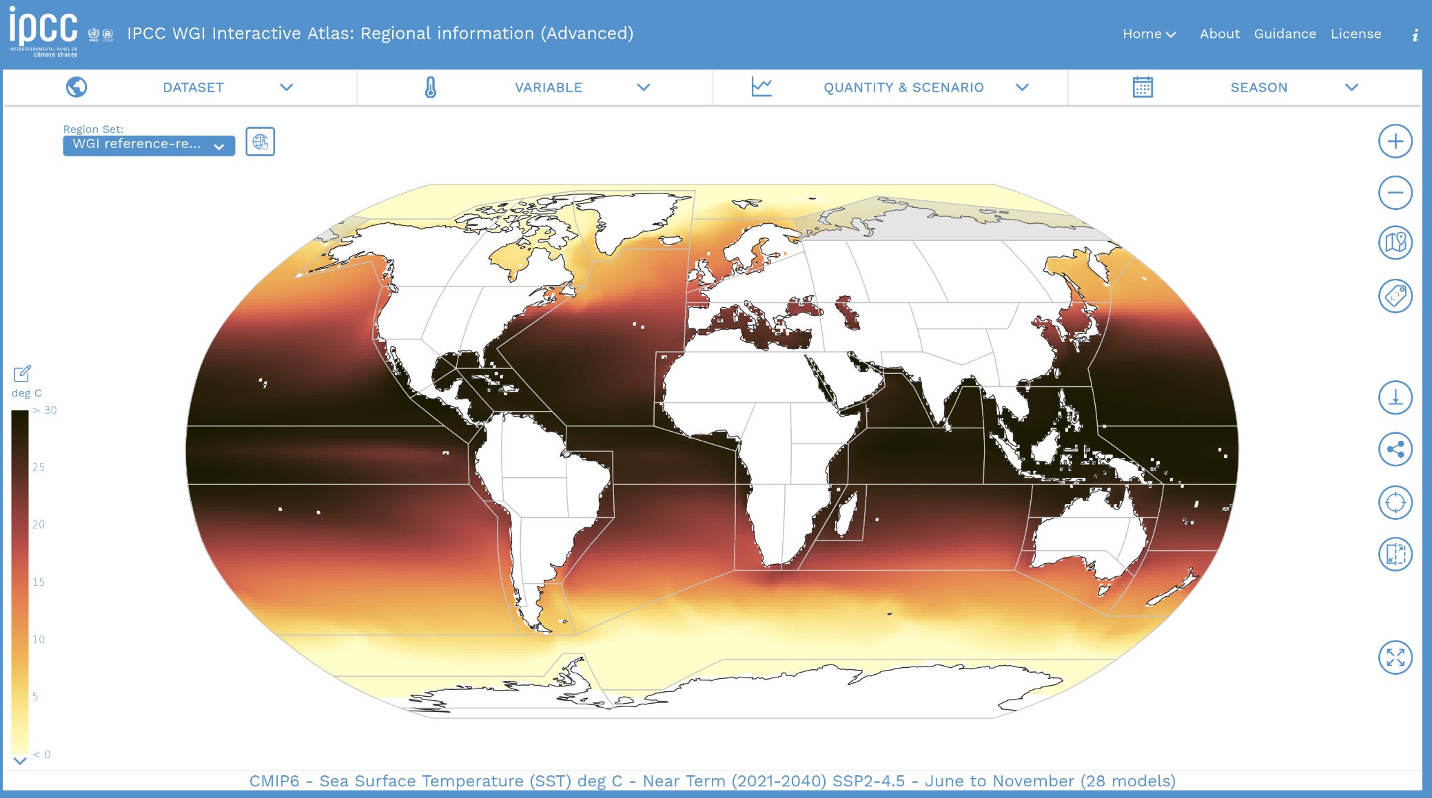
Figure 4: Expected Sea Surface Temperature for 2021 - 2040 Averaged for June – November, IPCC WGI Interactive Atlas.
Temperature differences between the Sahara region and the Gulf of Guinea are also expected to increase with climate change. The following two figures shows the change in temperature between 2021 – 2040 and 1850 – 1900 for the Gulf of Guinea and the Sahara.
On average, there has been a 1.4° C (2.5° F) warming in the Gulf of Guinea region and a warming of 2.3° C (4.1° F) over the Sahara since historical times. Relatively speaking, there has been greater warming over the Sahara than the Gulf of Guinea region. This growing temperature difference with climate change has the potential to create a stronger African Easterly Jet and the generation of more tropical waves.
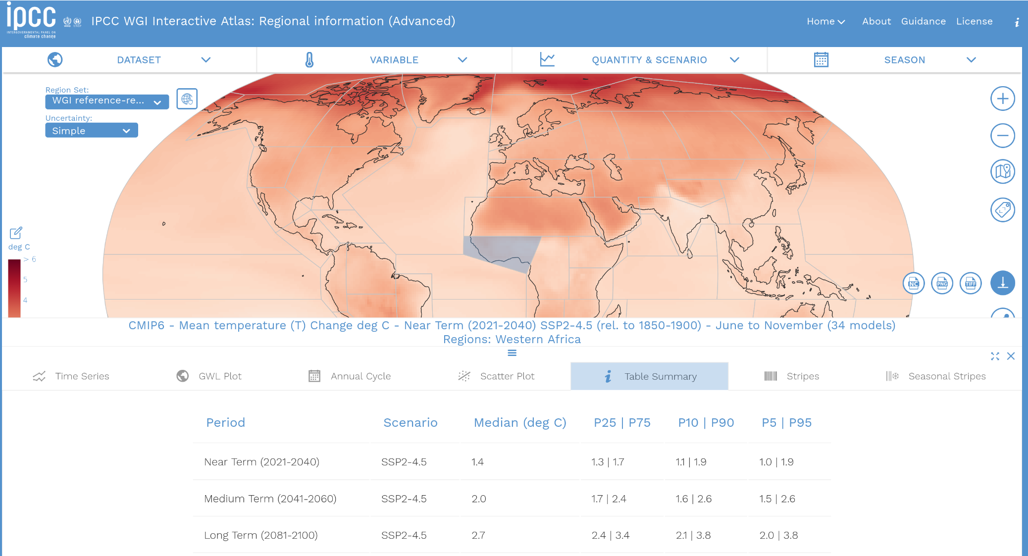
Figure 5: Gulf of Guinea Region: Surface Temperature Change Expected for 2021 - 2040 Compared to 1850 - 1900 Period Averaged for June – November, IPCC WGI Interactive Atlas.
Figure 6: Sahara Region: Surface Temperature Change Expected for 2021 - 2040 Compared to 1850 - 1900 Period Averaged for June – November, IPCC WGI Interactive Atlas.
Surface wind speeds over the Atlantic Ocean and Caribbean Sea are also expected to weaken over 2021 – 2040 compared to the historical period. The following figure indicates an average weakening by 1.7% in the near future.
While surface winds are not a measure of the vertical wind shear, it does indicate that winds are weakening with a warming world. This stands to reason as when the temperature difference between the tropics and polar regions weaken with a warming world, so too does the winds speeds. The upper levels in the atmosphere are also expected to warm and therefore winds can potentially be weaker with altitude in comparison to our historical period.
With weaker surface winds, there will be greater humidity and heating resulting in greater convection potential and enhanced ingredients for hurricane development and intensification.
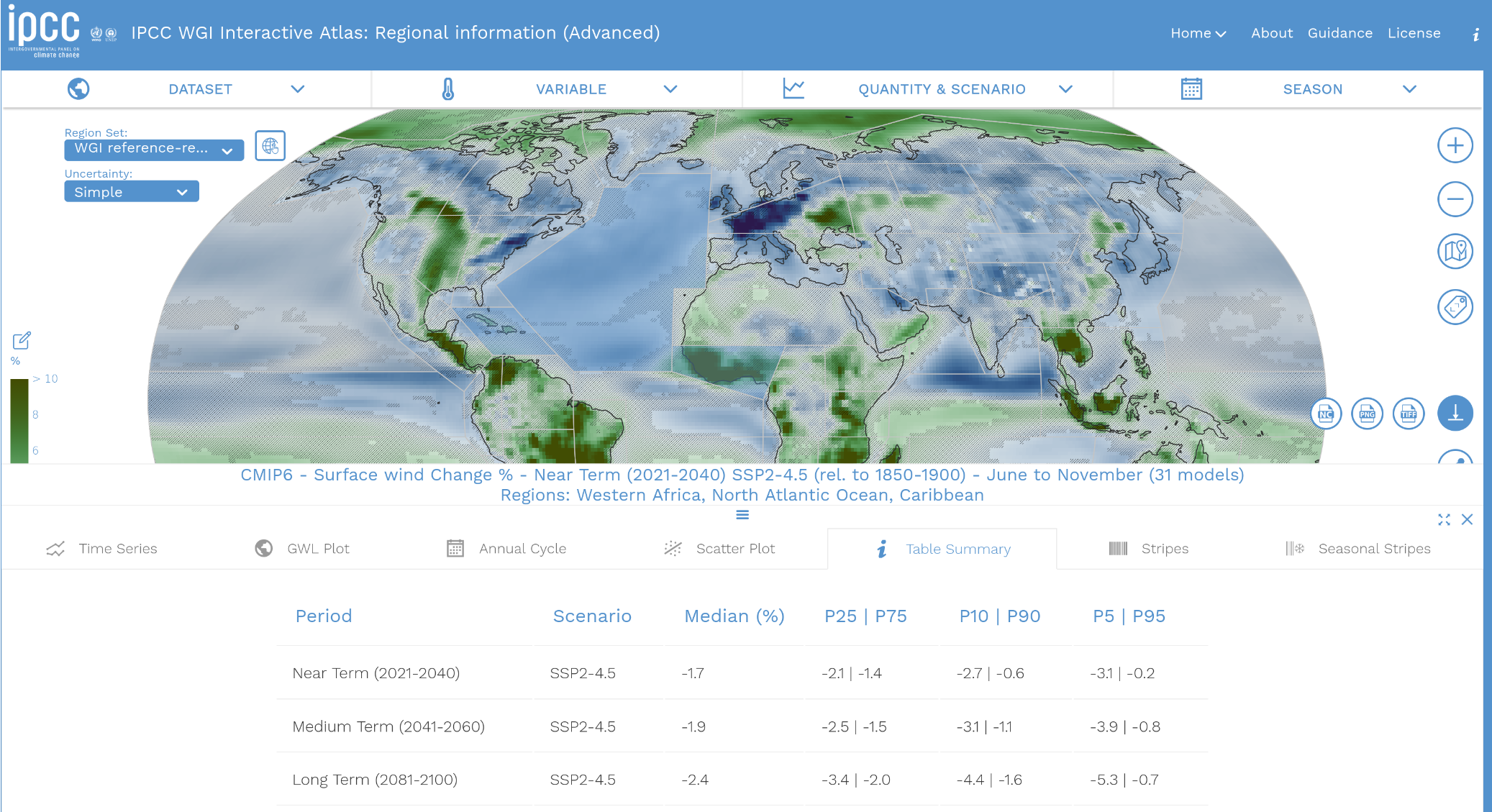
Figure 7: Atlantic + Caribbean: Surface Wind Change Expected for 2021 - 2040 Compared to 1850 - 1900 Period Averaged for June – November, IPCC WGI Interactive Atlas.
In conclusion, as our world warms with increasing GHG emissions combined with deforestation and degradation of other sinks, the ecosystem’s capacity to remove GHGs from the atmosphere is being degraded. We can therefore expect a greater frequency of hurricanes in the Atlantic Ocean, Caribbean Sea and Gulf of Mexico.
We can also expect them to be stronger and more devastating when they make landfall. Even hurricanes that do not make landfall and spend their life at sea, are a danger to shipping. This will impact supply chains and increase costs in terms of insurance and delayed shipment of goods and materials.
Adapting To Change
Coastal areas are most vulnerable to the devastation caused by hurricanes. Small island states in the path of hurricanes cannot avoid this. However, the further communities and buildings are from the coast the better they will fare.
Hurricanes cause storm surges that can sweep buildings away and cause extensive flooding. Heavy rains are produced which also add to flooding and landslides. The severe winds cause major damage to buildings and infrastructure.
Our standard practices of development now need to be updated to reflect our current reality given our changing climate and devastating hurricanes and tropical storms. Our adaptive options are more costly and require community or government involvement. Improving building standards to be more resistant to hurricane damage is essential in many coastal jurisdictions.
A stop-gap measure can be discouraging development along the coast. However this has negative impacts to tourism which is a primary industry for many jurisdictions.
The restoration of wetlands and mangrove swamps can help mitigate the impacts of storm surges and flooding. Avoiding encroaching into natural areas helps to preserve these areas and provides a cost effective nature-based solution to resilience and sustainability.
Catastrophe Bonds, a form of insurance that transfers the risk to investors, can be purchased to share the risk of major disasters such as hurricanes. These instruments have gained popularity in recent years due to the increased occurrence of extreme and catastrophic weather driven events. Jamaica purchased such a cat bond which will help cover some of the losses caused by Hurricane Melissa.
Resources
Environment and Climate Change Canada, How and where tropical cyclones form:
IPCC WGI Interactive Atlas,
https://interactive-atlas.ipcc.ch/
CBC, How Jamaica took out an insurance policy for itself, and why it’s about to pay off after Hurricane Melissa, https://www.cbc.ca/news/science/jamaica-hurricane-melissa-bond-finance-9.6958943
Music
Rootswise: 70s & early 80s Roots Reggae Selection
Thanks for reading Bits & Bytes of Climate Science! If you enjoyed this post, please click ♡ below, and help Bits & Bytes of Climate Science reach a wider audience.