

By Sam Kaharabata & Mishtu Banerjee
Yet Another Polar Vortex
According to AP News,
“The coldest burst of Arctic air this season is coming to put an icy exclamation point on America’s winter of repeated polar vortex invasions, meteorologists warn. And it will stay frozen there all next week.
Different weather forces in the Arctic are combining to push the chilly air that usually stays near the North Pole not just into the United States, but also Europe, several meteorologists tell The Associated Press.
This will be the 10th time this winter that the polar vortex — which keeps the coldest of Arctic air penned in at the top of the world — stretches like a rubber band to send some of that big chill south, said Judah Cohen, seasonal forecast director at the private firm Atmospheric and Environmental Research. In a normal winter, it happens maybe two or three times.”
Ten times and it’s only February 19th! What can you do to prepare for and adapt to these frequent cold spells. In today’s article we will cover :
understanding polar vortex and polar jet streams
how polar vortexes and polar jet streams are affected by climate change
why polar jet streams directed south are often associated with heavy snow fall
using the “Look up, Look down, Look around” approach to monitoring risks and managing damages
Polar Vortices & Polar Jet Streams
To orient ourselves we need to keep in mind that in meteorology, atmospheric “temperature” and “pressure” are used interchangeably because they cause similar outcomes. Warm temperature —> rising air —> low pressure —> rain or snow and the opposite causes clear colder weather. So a temperature difference results in a pressure difference between two regions. We’ll focus on temperature which is more familiar.
What is a polar vortex? We popularly refer to the region of cold air in the polar region as a polar vortex. However, this is not technically correct as the polar vortex is defined as a single vortex with a jet stream. The cold Arctic air mass, to the north, is confined by this vortex.
What is a polar jet stream? It is a band of fast moving air going from west to east caused by the difference in temperature between the cold Arctic air mass and warm mid-latitudes air mass. The polar vortex and the polar jet stream mutually influence each other.
The jet stream is formed at the boundary of these two air masses — northern polar air mass and more southerly mid latitude air mass. This polar jet stream, which usually flows at speeds of a few hundred kilometres per hour (couple hundred miles per hour) is found between the 50th and 60th parallel or degrees latitude over Canada.The waviness of the jet stream is caused by the earth’s rotation. During winter, when the temperature difference is greatest between the Arctic and mid-latitudes, the jet stream is the strongest.
The Role of Climate Change
“I thought global warming was going to do away with very cold winters!”
It’s a bit more complicated than common intuition. The Arctic is warming quite fast, and so is the rest of the world. So the difference in temperature between the Arctic and mid-latitudes is weaker, and we have a weaker jet stream. This is especially true in winter.
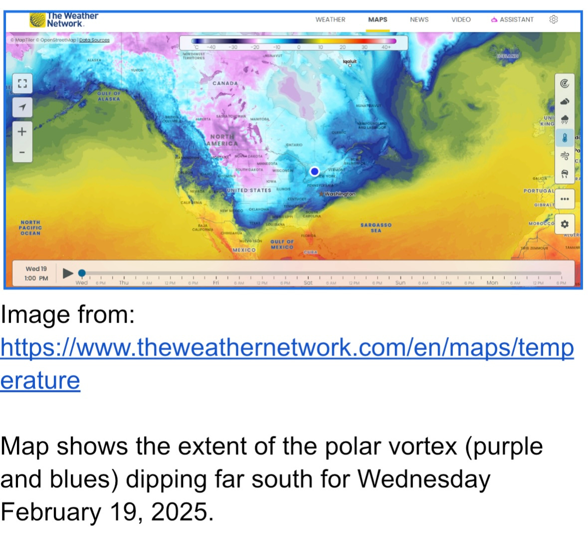
A weaker jet stream cannot contain the cold air in the Arctic. Flowing slower, it gets wavier and can break. If the dip south (the trough) of the jet stream’s wave is over land then it brings the cold Arctic air further south and now it is way colder in that location than it used to be. See the Weather Network map above showing the extreme temperatures. As our climate changes, this will become more frequent and hazards associated with cold extremes will increase in frequency and severity. So essentially warming of air in the far north weakens the temperature differential between north and mid latitude regions. It is now unable to keep the cold Arctic air IN the Arctic; it moves into the mid latitudes; and is colder than the air it displaces.
Polar Jet Streams & Snowfall Risk
Where does bad weather and snow fall the most?
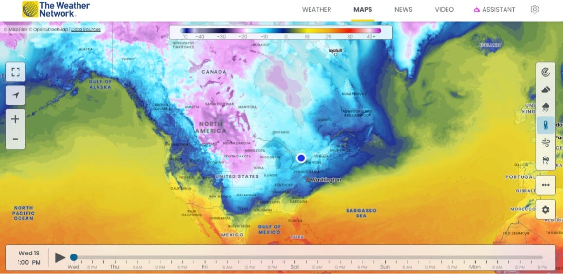
https://www.theweathernetwork.com/en/maps/temperature
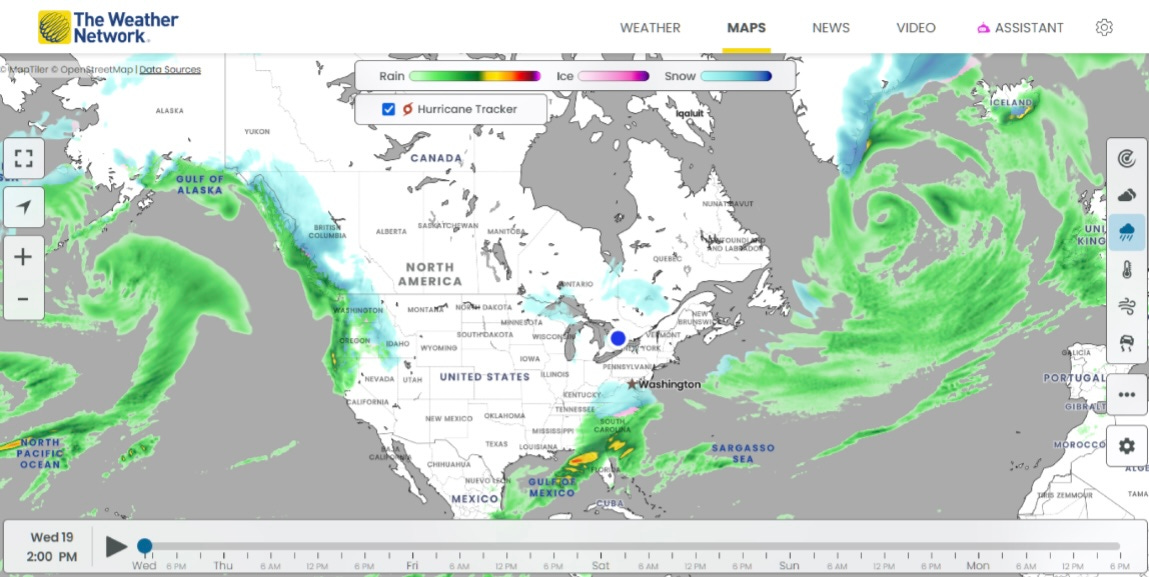
https://www.theweathernetwork.com/en/maps/precipitation
The first map above displays temperature and we can clearly see the boundary between cold Arctic and warm mid-latitude air masses. The boundary is where the polar jet stream is located. The southern dip or trough sits over Texas. Bad weather usually happens along the leading edge of the trough to its east. You can see that in the second map above which shows precipitation along the Gulf and up to Washington. Here, warm moist air is taken north, following the jet stream, and is mixed with even colder air from the deepening trough. This causes significant atmospheric instability along the leading edge of the trough through a lot of rising air and resulting heavy precipitation. You can see this in the second map above. Earlier in January, this “polar vortex - jet stream - trough” combo was further north resulting in the dumping of snow and bad weather we experienced in the lower states. It was not normal for the effects of the jet stream to go so far south. This illustrates how climate change related warming in the far north creates conditions for cold extremes much farther south. A seeming paradox is that one of the consequences of global warming can be more cold extremes.
Look Up, Look Down, Look Around
Look Up: We often have fair warning (1 - 2 weeks) of oncoming cold weather originating in weakening of northern jet streams temperature differential between mid latitudes. These are a regular part of meteorological forecasts. The Weather Network maps we used are just one source. If you have a favourite source for such information, please let us know and we will add to our resources page.
Look Down: We can observe temperature very locally on any weather forecast or via an outdoor thermometer. We are then able to determine if the temperature is rising or falling. As temperature falls, there is a reduction in the moisture carrying capacity of air. So for a given moisture level, as air rapidly cools, the chance of precipitation increases. If the temperature is below 0 C (32 F) precipitation occurs. With increases in cold spells we need to think about the insulation in our houses, whether windows need to be double glazed, and if we need extra heaters. And we need to understand the energy cost consequences of these decisions including redundancy and backup generators.
Look Around: A few of the things we need to think about are terrain, transportation, and health and safety, including hypothermia, especially in regions not accustomed to cold weather. If our homes are nested within mountainous areas we have to worry about the possibility of avalanches. If we have large trees near our house that are taller than our rooftops, we have to worry about large branches cracking under heavy snow loads and even whole trees falling onto our roof. In general the cylindrical profile of conifers sheds snow more easily than hardwoods. Finally, heavy snow loads can take out roofs and power lines. Downed power lines can create local outages and live wires pose a fire and safety risk. Cold temperatures can also result in frozen pipes and water main ruptures with local flooding. Transportation can also be impacted with dangerous icy or snow covered roads posing a safety hazard. When cold temperatures are above freezing, it can lead to freezing rain, heavy rains and potential flooding. All of these negative consequences can increase insurance rates.
Adapting to Change
The buildings we work and live in were designed under historical building codes and standards that did not account for our increasing extremes in weather. These standards now need to be updated to reflect our current reality given our changing climate.
Our options are to upgrade or retrofit our existing buildings and adapting our behaviours when we cannot upgrade. New buildings should be built to standards that incorporate climate change projections to at least 50 years into the future.
Resources
AP News - 10 Polar Vertexes So Far:
https://apnews.com/article/cold-icy-polar-vortex-winter-freezing-850b99054b73770de43db1b1918ee8c5
Polar Vortexes and Polar Jet Streams :
https://climate.mit.edu/explainers/polar-jet-stream-and-polar-vortex
Additional reading on jet streams and its weather:
https://opensnow.com/news/post/understanding-ridges-and-troughs
https://www.cbsnews.com/news/bitter-cold-central-us-deadly-flooding-south/
Floods When Cold front is above freezing
https://www.cbsnews.com/news/bitter-cold-central-us-deadly-flooding-south/
Deeper Dive Into Planetary Circulation Systems (Vortices, Jet Streams, Surface Circulation & Climate Change)
Louden Ross, S. 2024. Weather & Climate An Introduction. 3rd Edn. Chapter 12. The Planetary Circulation System.
Thanks for reading Bits & Bytes of Climate Science! If you enjoyed this post, please click ♡ below, and help bits & bytes of climate science reach a wider audience.
Subscribe for free to receive new posts and support my work
I can imagine you must be getting very tired of this by now. Everyone I know who is living on the East coast is getting depressed. Thankfully, spring is creeping closer. Hope you get some relief soon.